Geodemographics - blogs and resources
Visit the Geodemographics Knowledge Base (GKB) for expert blogs and links to useful sources of geodemographic data and knowledge.
The MRS Census and GeoDems group champions new thinking and new talent; one area they have been particularly impressed with is the CDRC Masters Dissertation Scheme (MDS)
This programme offers an exciting opportunity to link students on Masters courses with leading retail companies on projects which are important to the retail industry. The scheme provides the opportunity to work directly with an industrial partner and to link students’ research to important retail and ‘open data’ sources. The project titles are devised by retailers and are open to students from a wide range of disciplines.
MRS CGG are proud to have been granted permission to publish abstracts from the dissertations and we are sure the students have a great future ahead of them.
This abstract is by Margaux Leblanc, titled: Predicting car park occupancy rates from satellite images with a deep learning model
Academic Institution: University College London
Industry Sponsor: Sainsbury's
Background and Motivation
Sainsbury’s was interested in using new forms of data like satellite imagery to investigate the potential relationship between supermarket car parks’ occupancy rates and in-store retail intensity.
The last 30 years have brought a series of rapid scientific and technological advancements, which both satellite imagery and artificial intelligence have been spectacular sites of. Spatial images’ increasing quantity, quality, and accessibility has triggered a rise in the prevalence of their use in computer vision for analytic purposes. Satellite imagery’s resolution has increased so much in the last couple of decades that it has become a new data source for the extraction of small-scale objects, such as vehicles. Only a few studies have focused on vehicle detection using satellite images whose resolution is in the range 0.6–1.0m, but they have shown promising results. The methods to achieve small-scale feature detections are still being developed, and there is no definite path to follow in terms of data collection, image transformation, or model and parameters to use. This study is unique in that it seeks to contribute to the understanding of car parks’ occupancy rates and generate insights into consumers’ behaviour for the retail sector. Moreover, it does so, using open and free satellite images for at several set locations across the UK.
The study’s overarching objective is to devise a method, and specifically build an analytical tool that enables the extraction of vehicle features from open access satellite images and estimates car parks occupancy rates.
Based on the proposed project’s aim and previous work in the field of vehicle detection, the following research questions were derived:
1. Can an algorithm detect and count vehicles in car parks, and ultimately estimate their occupancy rates, using open access satellite imagery?
2. How does object detection specific algorithm YOLO perform with this task?
3. What are the main difficulties in detecting vehicles in car parks at specific locations in the UK with the available satellite imagery?
Data and Methods
A car park image library was built collecting 110 high-resolution satellite images at 19 Sainsbury’s stores’ locations in the UK from Google Earth Engine. Most images were cropped and tilted as initial tests suggested these transformations would increase detections’ accuracy. A pre-trained, object-detection specific, deep learning algorithm, YOLOv4, detects, localises, and counts the vehicles, which serves the car parks’ occupation rates calculations. This method and the algorithm performance were quantitatively and critically evaluated, to facilitate potential future research.
Key Findings
The pipeline for car park occupancy level estimation based on vehicle detection from satellite images is complete, functional, and produces the expected outputs (Figure 1).
However, the model significantly underpredicts the number of objects in car parks. The number of detections made by the model for each car park explains 10.8% of the count of vehicles observed at the different locations (Figure 2). There is also significant variation in detection accuracy from one car park to another (Figure 3).
There seems to be a positive and significant relationship (R² = 0.59) between the car parks’ occupancy rates based on the observed number of cars and the number of objects detected by the model. However, because the sample size is small, these results may not be representative of the algorithm’s performance, and inference based on them would not necessarily be conclusive. Possible explanations for the model’s failed detections are the lack of data at a suitable format, which is a common constraint in similar studies, and a high number of clustered objects per image. Overall, the model’s performance on the input data was insufficient for the methodology to be generalised as such, but this method could be applied to another dataset. Nonetheless, this study shows that it is technically possible but complex to detect and count cars at set locations in the UK using open access satellite imagery with a deep learning object detection algorithm. Optimising the pipeline and automating more steps would improve the analysis results and the study’s reproducibility. Future studies could attempt to re-train the model with data similar to this input, acquire images at a resolution and format that better suits the model, implement a variety of image transformation and detection validation techniques, or combine these strategies. Also, evaluating the algorithm using detections’ accuracy, precision, recall and confidence scores on a bigger sample size would help uncover its strengths and weaknesses.
Value of the research
Creating a reliable car park occupancy classification tool would be useful to examine the hypothetical relationship between car park traffic and in-store trade intensity, notably at different temporal scales. It might eventually be possible to analyse spatial variation in carpark occupancy across the Sainsbury’s stores and gain insights into retail competitors' market shares. The methodology developed and its evaluation could also be applied for problems relating to general traffic and parking space monitoring, as part of the smart mobilities and smart cities agenda in urban planning, or for economic forecasting purposes.
Figure 1: Example of a successful car detection by YOLOv4’s on a zoomed-in image of a Sainsbury’s car park.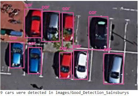
Figure 2: Linear relationship between the predicted number of objects and the observed count of vehicles.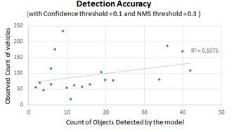
Figure 3: Output of YOLOv4 on an overview image of a Sainsbury’s car park, showing above average accuracy at a very zoomed-out scale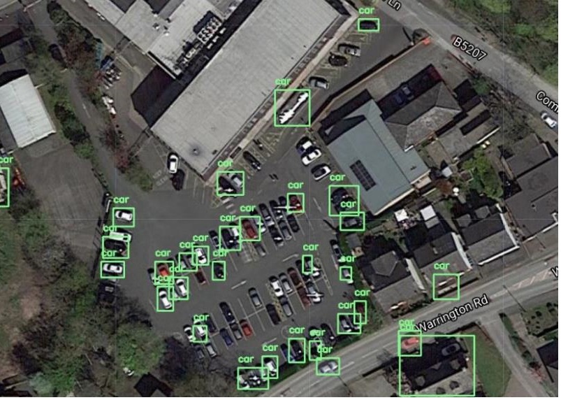

Visit the Geodemographics Knowledge Base (GKB) for expert blogs and links to useful sources of geodemographic data and knowledge.
Our newsletters cover the latest MRS events, policy updates and research news.


©2026 The Market Research Society,
15 Northburgh Street, London EC1V 0JR
Tel: +44 (0)20 7490 4911 Email: info@mrs.org.uk
The Market Research Society (MRS) is the world's leading research association. For all those who need, generate or interpret the evidence for making good business and policy decisions. Click here to find out more about us.
©2026 The Market Research Society,
15 Northburgh Street, London EC1V 0JR
Tel: +44 (0)20 7490 4911 Email: info@mrs.org.uk
0 comments