Geodemographics - blogs and resources
Visit the Geodemographics Knowledge Base (GKB) for expert blogs and links to useful sources of geodemographic data and knowledge.
The MRS Census and GeoDems group champions new thinking and new talent; one area they have been particularly impressed with is the CDRC Masters Dissertation Scheme (MDS)
This programme offers an exciting opportunity to link students on Masters courses with leading retail companies on projects which are important to the retail industry. The scheme provides the opportunity to work directly with an industrial partner and to link students’ research to important retail and ‘open data’ sources. The project titles are devised by retailers and are open to students from a wide range of disciplines.
MRS CGG are proud to have been granted permission to publish abstracts from the dissertations and we are sure the students have a great future ahead of them.
This abstract is by Szymon Ignacy Padlewski
Title: Inferring modes of transportation from raw unlabelled GPS data using Convolutional Neural Networks
Academic Institution: University College London
Industry Sponsor: Movement Strategies
Background and Motivation
The comprehension of the peoples' transportation patterns, travel behaviours and the modal split of individuals' journeys are essential insights used for demand analysis, traffic management, or optimisation of travel time. Gathering data on commuters’ behaviour in cities has been traditionally, conducted through household interviews or phone questionnaires. Nonetheless, collecting modal statistics utilising such methods is laborious, financially expensive and troublesome, due to low response rate, data accuracy and reliability issues. However, the ubiquitous presence and widespread application of Global Positioning System (GPS) technology in everyday life devices have open new possibilities for gathering accurate information regarding peoples transportation choices. With the enormous market penetration of this location-sensing technology, vast datasets are being registered daily , allowing for new applications and individuals’ travel pattern analysis.
The aim of this work is to investigate whether modes of transport can be reliably identified from unlabelled GPS data using state-of-the-art classification methods such as a convolutional neural network trained on the dissimilar labelled GPS dataset. The objective of such an approach is to establish a unique framework enabling for wider application of existing transportation modes identification techniques on enormous raw GPS datasets gathered daily through various smartphone apps. Additionally, this thesis will also attempt to create a methodology that would contribute to knowledge by setting an architecture for future testing of new classifiers, refining results obtained by this research.
Data and Methods
In this project, the user's modes of transport are inferred using data from everyday devices with GPS capabilities through the utilisation of a convolutional neural network (CNN). Moreover, this work enhances the already established techniques relying solely on motion features extracted from GPS data for training the model by proposing the inclusion of proximity features, calculated using transportation networks characteristics points' locations. The CNN models are trained on a separate set of features which predictions are inserted in the logistic regression model to derive the ultimate classification. Additionally, in this dissertation, the unlabelled GPS trajectories go through various phases, such as cleaning pre-processing, extraction of single-mode stages, and data segmentation to match the CNN classifier’s input layer requirements. Furthermore, the proposed unique methodology enables to tests whether users' modes of transport can be reliably identified from raw unlabelled GPS data gathered using a heterogeneous set of GPS devices and from a dissimilar region than the dataset used for training the models.
Key Findings
The proposed CNN approach combining two kinds of classifiers is based on an ensemble technique called stacked generalisation and proved to be beneficial for the inferring process. The model's accuracy level achieved while solely utilising motion features for training and classification has been strengthened from 82.3 per cent to 83.6 per cent by employing the proposed technique. The 1.3 per cent improvement compared to the existing transportation modes classifiers using CNN depicts a notable potential of the suggested technique. Since this study uses a CNN's architecture proposed by Dabiri and Heaslip (2018), the obtained results might be enhanced by rigorously testing a wide range of CNN layer configurations to establish a more suitable CNN setup for a model using proximity features. However, the effectiveness metrics calculated after manually validating samples of unlabelled GPS trajectories classified by the CNN model mentioned above haven't been sufficient to prove the truthfulness of our core hypothesis. The best overall accuracy of the validation sample measured in this study reached 49 per cent, with an average f-score of 48 per cent.
Value of the research
The proposed method in this dissertation has demonstrated a notable potential, before unexplored to the author’s knowledge, in enhancing transportation modes identification through the stacking process of CNN models relying on different sets of users’ trajectories’ characteristics. Such an approach mitigates potential problems with feature selection and dimensionality reduction. Moreover, this study has depicted and performed a detailed pre-processing phase enabling the usage of CNN classifiers on unlabelled raw GPS trajectories gathered by a heterogeneous set of GPS devices. The unlabelled GPS data has been transformed into a format complying with CNN’s input layers requirements through noise reduction and data cleaning, change stop detection, single-mode stage identification, and feature extraction.
Even though the established results haven’t been sufficient enough to consider the process reliable, with the overall accuracy of the validation sample of 49 per cent and the average f-score of 48 per cent, nevertheless, thisdissertation with its unique methodologyframework can be seen as a proof of concept, anda starting point for future work. In the end, thisdissertation has successfully met all the objectivesset out at the beginning of the study andcontributed to knowledge by helping in paving apath towards the real-world application oftransportation modes detection using rawunlabelled GPS data.
Fig 1– Shows the diagrammatic representation of the three-phased methodology established for this dissertation.
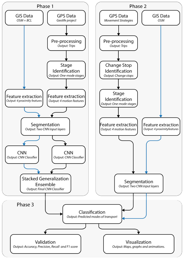
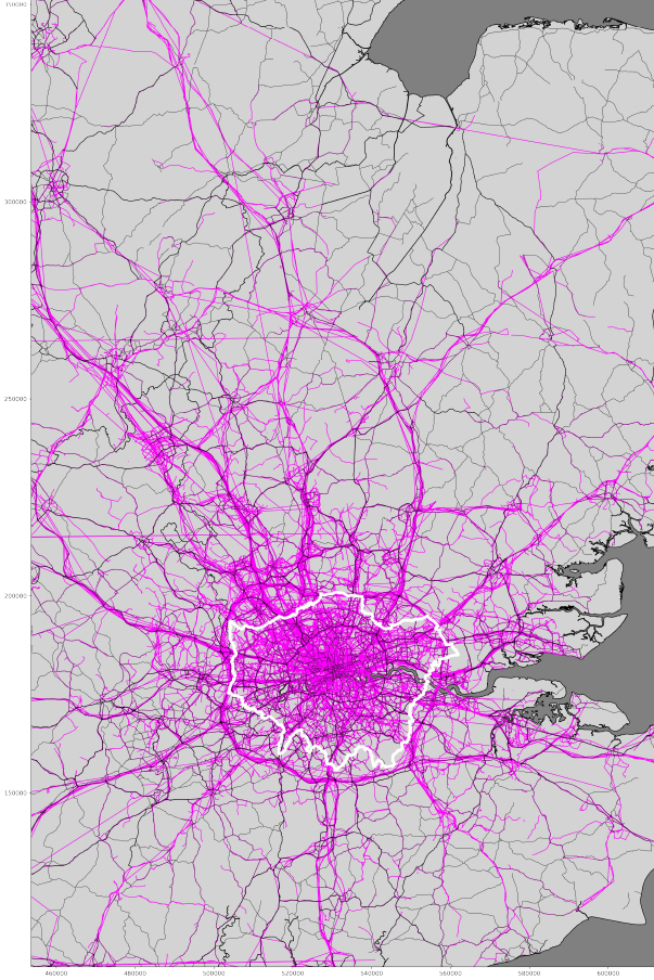
Fig 2– Depicts a map of London and Surrounding Areas with Group three’s segments classified as a driving mode by the CNN model in pink and major roads in black.
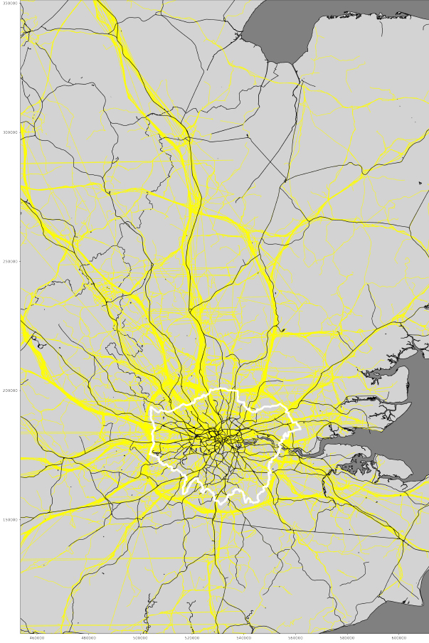
Fig 3– Depicts a map of London and Surrounding Areas with Group three’s segments classified as a train mode by the CNN model in yellow and railway network in black.

Visit the Geodemographics Knowledge Base (GKB) for expert blogs and links to useful sources of geodemographic data and knowledge.
Our newsletters cover the latest MRS events, policy updates and research news.


©2026 The Market Research Society,
15 Northburgh Street, London, UK EC1V 0JR
Tel: +44 (0)20 7490 4911 Email: info@mrs.org.uk
The Market Research Society (MRS) is the world's leading research association. For all those who need, generate or interpret the evidence for making good business and policy decisions. Click here to find out more about us.
©2026 The Market Research Society,
15 Northburgh Street, London EC1V 0JR
Tel: +44 (0)20 7490 4911 Email: info@mrs.org.uk
0 comments