Geodemographics - blogs and resources
Visit the Geodemographics Knowledge Base (GKB) for expert blogs and links to useful sources of geodemographic data and knowledge.
UCL’s Department of Geography has long been at the forefront of Geodemographics Research. With public outputs including the 2011 Output Area Classification (Below), the 2011 London Work Place Zone Classification and the department has also received funding for the production of the 2021 Output Area Classification in collaboration with the Office for National Statistics (ONS).
More recently, under the UCL-based Consumer Data Research Centre (CDRC), researchers have been amalgamating consumer and administrative datasets and applying novel analysis on them to generate new representative geodemographic products on the population that are unshackled from the slow and infrequent temporal refreshes of the Census statistics.
The newsletter below briefly takes a glance at some of the new geodemographic insights the CDRC have produced. For UK based viewers, the interactive maps below will enable you to explore trends in your areas. For more a more detailed look at the data please visit CDRC Maps
The 2011 Output Area Classification. Full map available here.
One of the CDRC’s most ambitious products in the construction of a Linked Consumer Register (LCR), an individual-level database of almost all adult residents geocoded by addresses from 1997 onwards. The database comprises over 1 billion records from the public version of the Electoral Register and various anonymised consumer sources across the 20 year period, and it is updated annually. Through linkage exercises, it is possible to record the local adult-population changes at the address level. For instance, the Population Churn Index provides an aggregated metric which allows users to explore the extent to which neighbourhoods have changed between 2016 and the years prior. In the example below, the proportion of households that have moved in since the start of 2011. It highlights the extent to which some neighbourhoods might have changed since the collection of the most recent census.
The proportion of households that have moved in since the start of 2011 (as of 2016). Full map available here.
The LCR also offer opportunities to understand granular population characteristics on a range of different domains. For instance, ethnicity estimation software which estimates the most probable 2011 Census ethnicity category based on names was created in collaboration with the ONS to infer characteristics. The map below displays LCR ethnicity estimations at the Lower Super Output Area level. Users can use the bar at the top of the map to select the ethnicity and the year to explore their geographic distribution over time.
Forename and surname-based ethnicity prediction. Full map available here.
In addition to exploring the changing composition of neighbourhoods, an innovative algorithm was devised to estimate the origins and destinations of households that join or vacate different addresses. Roughly 45 million moves have been detected within 1997 to 2016. The subset from 2011 were found to correspond with the journeys recorded in the 2011 census, although the LCR can also look at movements in and out of specific areas across other specific timeframes. For instance, research has found that adults moving into gentrifying neighbourhoods tend to come from further distances on average than the destinations of those that vacate. In some locations, this can be indicative of displacement as a result of the increasing land prices that are perhaps more favourable to young professionals seeking privately rented accommodation in vibrant neighbourhoods.
For example, Spitalfields in East London has experienced considerable neighbourhood change over the past two decades as the area has gentrified. Research has found that a large share of those that have moved in originated from outside London whilst most that vacated moved elsewhere within the region. The map below displaying the outbound flows of adults that have left the Spitalfields and Banglatown Ward between 1997 and 2016. By visualising the most predominant ethnic group of each flow makes it is apparent that much of the pre-existing Bangladeshi population that left the area moved further into East London.
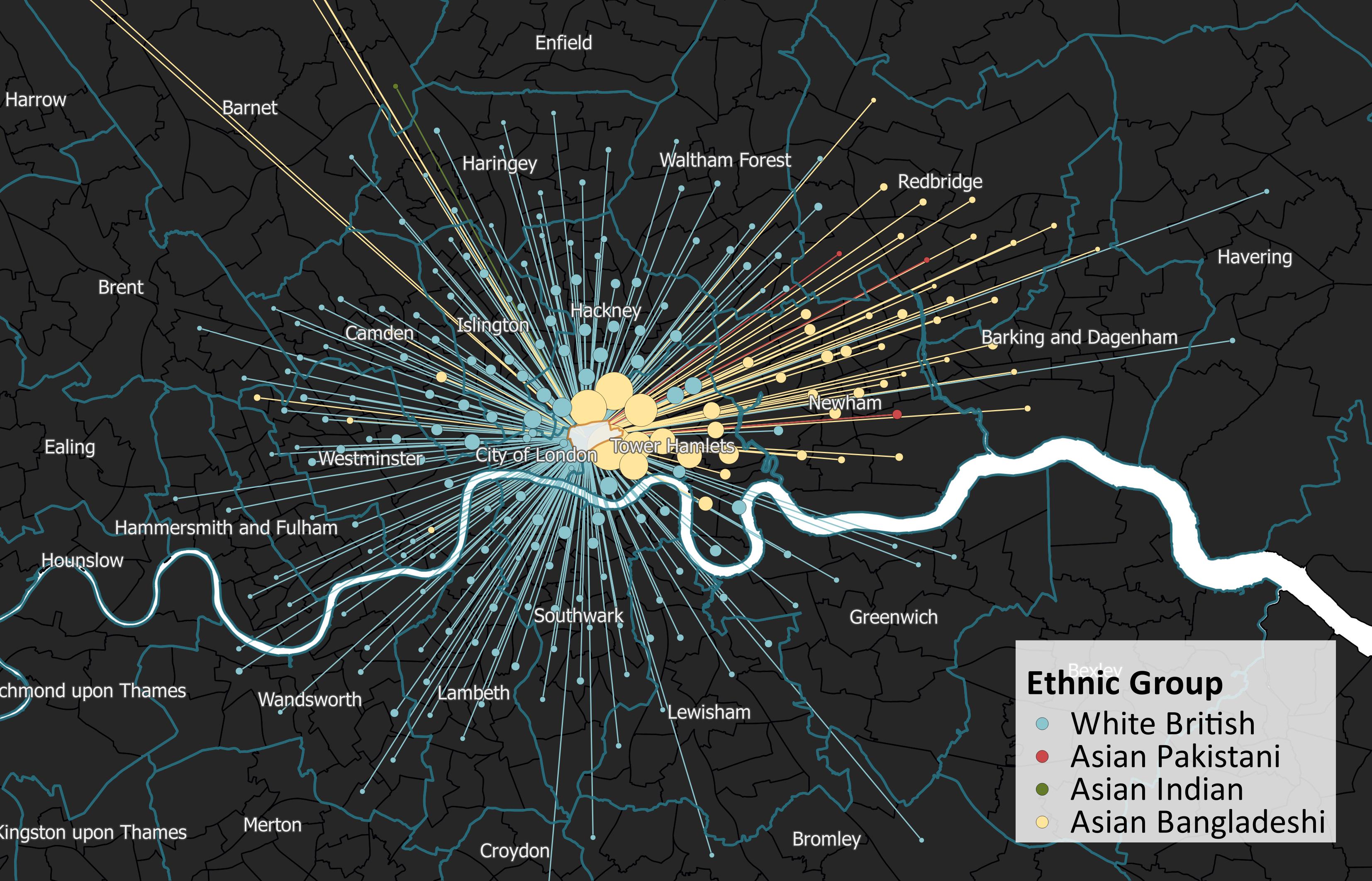 Migration out of Spitalfields (1997 until present). Coloured by the most predominant ethnic group of each flow. Only flows of at least 10 adults are shown.
The CDRC are currently in the process of acquiring and linking data for 2017 and 2018 to bolster the Linked Consumer Register. Currently, the outputs from the LCR are available for public intuitions upon application and partnerships have been formed with several local governments. This is especially timely given the growing enthusiasm for harnessing new forms of data to produce valid geodemographic insights due to the high costs of censuses and their infrequent collection intervals. Furthermore, the extremely high coverage of consumer datasets when carefully linked also facilitates the production of highly granular databases that can be repurposed to answer specific questions about the changing geodemographic composition of neighbourhoods across the UK.
Interactive maps created by Oliver O’Brien, a Senior Research Associate at University College London
 |
Guy Lansley is a Senior Research Fellow at the Consumer Data Research Centre, University College London. Guy is a researcher and data scientist with an interest in discovering real-world demographic trends from big datasets generated from consumer-facing organisations. |

Visit the Geodemographics Knowledge Base (GKB) for expert blogs and links to useful sources of geodemographic data and knowledge.
Our newsletters cover the latest MRS events, policy updates and research news.


©2026 The Market Research Society,
15 Northburgh Street, London, UK EC1V 0JR
Tel: +44 (0)20 7490 4911 Email: info@mrs.org.uk
The Market Research Society (MRS) is the world's leading research association. For all those who need, generate or interpret the evidence for making good business and policy decisions. Click here to find out more about us.
©2026 The Market Research Society,
15 Northburgh Street, London EC1V 0JR
Tel: +44 (0)20 7490 4911 Email: info@mrs.org.uk
0 comments