Geodemographics - blogs and resources
Visit the Geodemographics Knowledge Base (GKB) for expert blogs and links to useful sources of geodemographic data and knowledge.
The MRS Census and GeoDems group champions new thinking and new talent; one area they have been particularly impressed with is the CDRC Masters Dissertation Scheme (MDS)
This programme offers an exciting opportunity to link students on Masters courses with leading retail companies on projects which are important to the retail industry. The scheme provides the opportunity to work directly with an industrial partner and to link students’ research to important retail and ‘open data’ sources. The project titles are devised by retailers and are open to students from a wide range of disciplines.
MRS CGG are proud to have been granted permission to publish abstracts from the dissertations and we are sure the students have a great future ahead of them.
This abstract is by Harry King
Title: Quantifying the carbon impact of the household
Academic Institution: University of Leeds
Industry Sponsor: CACI
Background and Motivation
Meeting net zero greenhouse gas emission targets will require a fundamental shift in the way that people live, work and travel In the UK, housing accounts for 21 of all greenhouse gas emissions, with 29 million homes in the UK needing to become low carbon and resilient to climate change to meet the governments net zero by 2050 target.
The "carbon impact" of the household extends further than most typically consider. Lifestyle, transport and consumption all factor into the overall carbon impact of a household.
This project used data from CACI and the UK Government to quantify the carbon impact of every household in Leeds, and defined a reproducible, easy to follow method that could be rolled out for the whole country.
Data
CACI’s address level Address Spine and Ocean datasets were the core datasets used in this project. Address Spine contains property level variables such as property type, number of rooms, tenure, house price and energy consumption. Ocean, CACI’s consumer database, contains demographic, digital, lifestyle and
attitudinal characteristics for individuals within UK households.
Additional publicly available data were used including EPC data, IMD and shapefiles.
Methods
The relevant variables were identified using literature and an estimated carbon total was calculated for each of the three domains of carbon emissions (transport and consumption). For domains where there were no pre existing carbon emission totals available, estimates were made using government predicted emissions and propensity scores from the Ocean dataset. Total carbon emissions were calculated by adding together the totals from the sub scores.
An additional investigation was performed into the relationship between the Index of Multiple Deprivation and household carbon emissions at LSOA level. Standard regression and Geographically Weighted Regression were used for this, and it was found that Education, Skills and Training Deprivation and Health Deprivation were significant negative predictors of carbon emissions
Key Findings
Results were mapped for each domain of carbon production
(Figure 1)
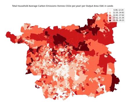
Figure 1: Total Household Average Carbon Emissions (tonnes CO2e per year) per
Output Area (OA) in Leeds.
Maps were also created for each domain, and slight variations were observed in the distribution of high and low carbon scores. Broadly, however, the patterns were the same. Generally household carbon emissions were higher outside of central Leeds, with the highest estimates found in the north of the city There are some areas of high emissions to the east of the city.
In Leeds, there is a wide variation in carbon emissions, with results ranging from 1 tonne per year to 65 tonnes per year for each household.

Visit the Geodemographics Knowledge Base (GKB) for expert blogs and links to useful sources of geodemographic data and knowledge.
Our newsletters cover the latest MRS events, policy updates and research news.


©2026 The Market Research Society,
15 Northburgh Street, London, UK EC1V 0JR
Tel: +44 (0)20 7490 4911 Email: info@mrs.org.uk
The Market Research Society (MRS) is the world's leading research association. For all those who need, generate or interpret the evidence for making good business and policy decisions. Click here to find out more about us.
©2026 The Market Research Society,
15 Northburgh Street, London EC1V 0JR
Tel: +44 (0)20 7490 4911 Email: info@mrs.org.uk
0 comments